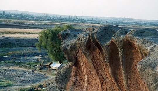
The site of Agarak is lying in the southern foothills of Mt. Aragats, is located on the western bank of the Amberd River and covers an area of 200 hectares, a portion of which (118 hectares) has now been declared a historical and cultural preserve by the government of Armenia. The site consists of horizontal flows of solidified tuff, which extend southward and have flat surfaces. They border on the East with the river, while in the West they turn into a hilly ridge. Taking into account the special characteristics of the local relief, formed by tuff flows, the inhabitants transformed the landscape at the cost of considerable effort, turning natural masses of tuff into a gigantic system consisting of collections of stone structures.

Downstream along the course of the Amberd river for dozens of kilometers extend without a break tuff cliffs, passages, rocky hills, and natural plateaus, as well as freestanding blocks of stone. On their surfaces and sides, these formations bear the traces of intensive stone working.
For the time being, excavations are being conducted only at the first cliff plateau of the northern complex of Agarak. The results of field investigations in 2001-2002 show that Agarak was settled starting in the early Bronze Age.
The layers overlaying the strata of the early Bronze Age are disturbed. They contain material remains confirming that the site was subsequently inhabited in various archaeological epochs, from the middle Bronze Age to the early Iron Age, inclusive. An amphora burial with an Urartian seal and the presence of many Urartian ceramic fragments permit us to speak as well of Agarak being inhabited from the 8 th to the 6 th century B.C. After the fall of the Van Kingdom, Agarak experienced yet another period of intensive development, becoming a large settlement of the urban type.
Within the limits of the Armenian Plateau and the territories bordering on it, no other such site is known. It is unique in terms of its unusual composition and design, as well as its volume and area.
Choose one of our tours to Armenia to enjoy beauty of Armenia with your own eyes.